PCT Day 95
August 3, 2021
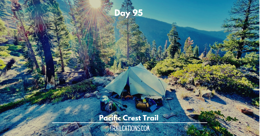
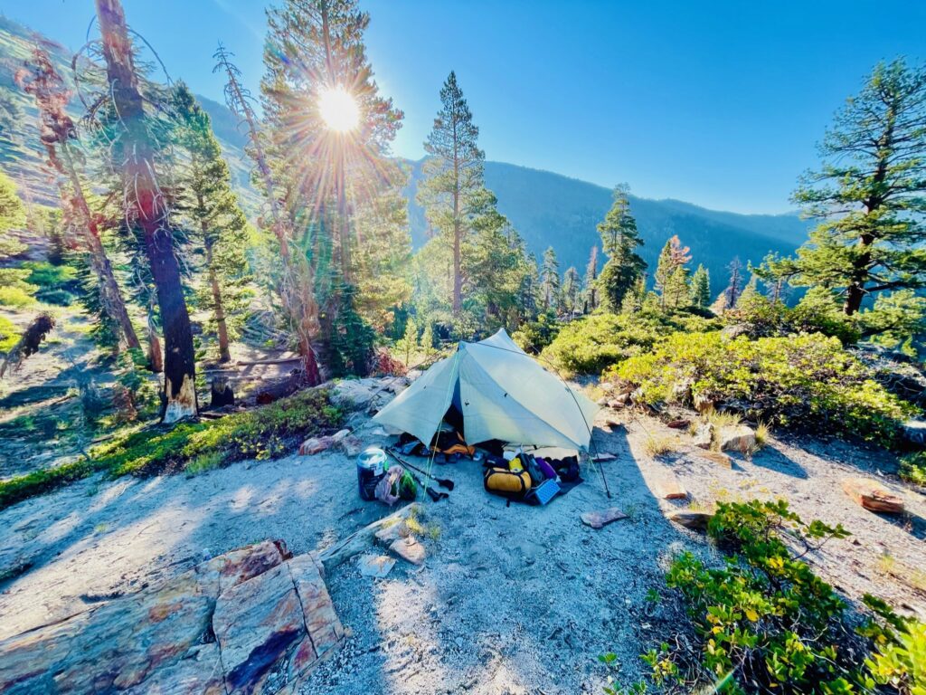
Mile: 915.9 to 915.0 (southbound 0.9 mile)
Start: Cliffside campsite above Agnew meadows
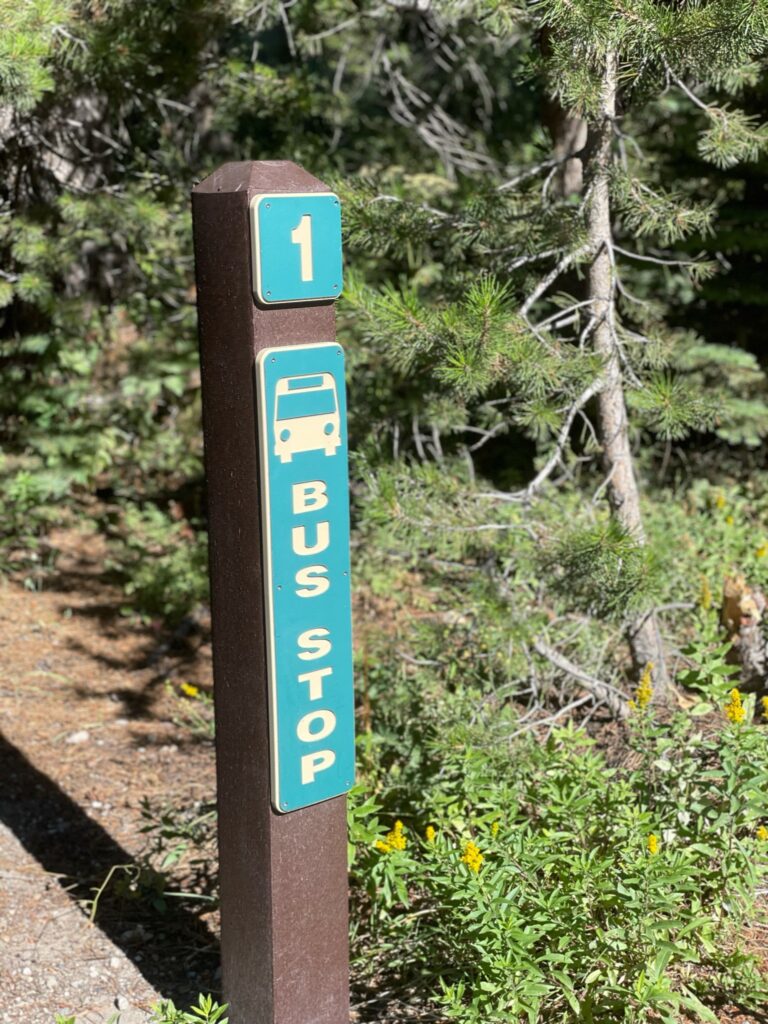
Finish: Shilo Inn at Mammoth Lakes via the bus Agnew Meadows
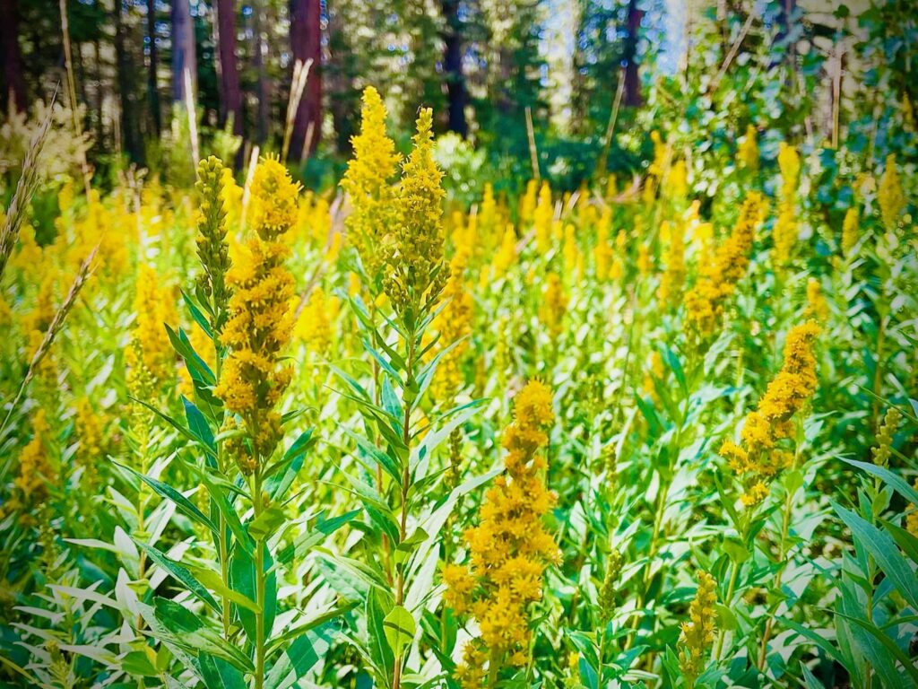
This morning I was super excited to wake up and start hiking because today we were going to cross into the famous Yosemite National Park, home of dramatic spires and mountains such as Half Dome, El Capitan and beautiful waterfalls and wildlife. We were so close to the eastern edge of the park’s boundary and I had never been to this park before. With how popular Yosemite National Park was combined with during the Covid pandemic everyone deciding they wanted to become an outdoor adventurer and hiker, Yosemite was accessible this year by a reservation only basis. The long lines of vehicles to get into the park were cut off at a certain time when reduced capacity numbers were reached. Luckily the quotas only applied to people coming in by car and by walking into the park we could bypass all the B.S. of quotas and reservations. We’d gone through that reservation and permitting crap several months ago while we waited hours in a virtual line with 13,000 other people to obtain our PCT thru-hiking permits.
Unfortunately this morning it seemed that we had to make a tough decision on whether we’d continue hiking 26 miles to the famed Yosemite National Park or self-evacuate from the backcountry immediately. Overnight, Shannon’s foot had swelled up again with a painful gout flare-up. The side of his foot was swollen in a red shiny ball under his big toe where tiny uric acid crystals had built up in painful shards, the microscopic slivers digging agonizingly into his muscle tissue and ligaments every time he even breathed. Without even moving his foot, you could see Shannon gritting his teeth with the painful injury. Most likely the flare-up came from him eating some of the hamburger and strawberry milkshake I ordered at Red’s Meadow backcountry resort yesterday. Red meat and sugary substances are high on the “no-no” list for people suffering from gout. When I asked Shannon if he thought it was wise to eat the burger and milkshake yesterday, he insisted that he was healed and it was fine for him to eat rich foods despite several medical professionals having told him to avoid this type of food. Well, with Shannon limping around to make breakfast this morning after eating meat and sugar, the situation clearly was not fine.
Our trek came to a crossroads this morning where we had to assess the risks of deciding whether to hike back 1 mile to catch the bus back into the city where Shannon could take some more time off to heal his injured foot or continue trekking 26 miles north into Yosemite with no bailout points before then on our maps. I was wincing just looking at how much pain Shannon appeared to be in. I gently reminded my hiking partner that he would have to not only be able to hike himself and his 30lb pack for a full marathon over 11,000 ft tall mountains, but that I would not be able to physically carry him out of the backcountry if the situation worsened. If we decided to continue north to Yosemite and Shannon’s foot injury intensified, we’d either have to wait for him to recover by staying a few extra days in our tent in the wilderness while rationing our food or call for Search and Rescue to support a full on backcountry evacuation. I reminded him that the trail will always be here and we could always come back after he’s healed to continue the trek.
It is an understatement that Shannon can be very stubborn sometimes but so can I. We rarely get in arguments but we will go toe-to-toe when it comes down to serious issues that have the potential to be life threatening. When I woke up this morning and saw his foot, I had already made up my mind that as Shannon’s hiking partner and teammate, there was no way I was going to continue hiking in the backcountry with his injury as it wasn’t worth the risks. I wanted Shannon to come to the decision on his own that he shouldn’t be hiking anymore and potentially risking both of our lives in the backcountry with his injury. It only took an hour for him to admit that we should turn around and I think this time the pain won out the argument. Despite all the frustration I was feeling at Shannon’s 100% preventable injury, I tried my hardest to remain empathetic and calm while leading him down the logical path of self-evacuation from the backcountry while we still had options of the road and shuttle bus being nearby.

In the end, we decided that it would be a lot smarter to just go back downhill a mile and catch the bus back to the city of Mammoth Lakes for Shannon to rest his foot. The entire way down the mountain, Shannon limped and winced painfully each time he put pressure on his foot. I don’t understand how he thought that he could have hiked essentially a marathon through rough mountain terrain with a heavy backpack, a single hiking pole (his other pole broke a few days ago) and his injured foot. Did I mention that sometimes Shannon can be a little bit stubborn? Guess we’re a good match!
Back in the town of Mammoth Lakes, the nice lady at the Shilo Inn was still working and she said today was her last day since her boss hadn’t paid her in three weeks. She gave us a generous discount on our room for the night and Shannon rested his foot while we made plans on what to do next. Over 400 miles of PCT north of us had been closed due to wildfires. We’ve been keeping a close eye on all the forest fires cropping up and it seems like almost hour to hour that parts of the Pacific Crest Trail are being closed or threatened because of the dozens of wildfires that are breaking out.
Unfortunately it’s not all that surprising that there are so many wildfires popping up because of how desiccated the landscape is out here. All of the vegetation is bone dry and the pine forests and sagebrush seem like they could go up in flames just by a misplaced fart in the backcountry! It is quite unfortunate all of these fires are popping up not only because of danger of loss of life, property and wildlands but because many of these trail town’s economies have been already stressed by the impact of Covid. Wildfires could be the nail in the coffin for many small businesses and people who work and live in the area. I think some of our resupply packages are going to be stuck in these little towns that we’ve mailed them to that are being evacuated due to the fires. Hopefully our packages didn’t burn up and hopefully we also don’t burn up while trying to dodge all the fires.
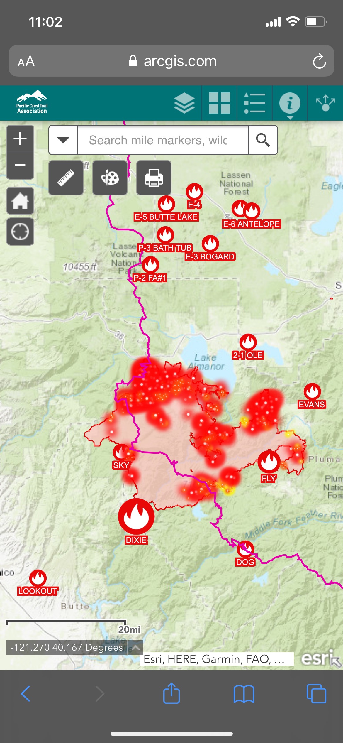
After a few hours we decided in terms of logistics, fire threats and the looming deadline of having to finish the PCT by the beginning of October when the winter snows start hemming in the trail in Washington that we were going to skip up to South Lake Tahoe where our friend Brad lived. Staying off trail and with our friend would give Shannon another couple of rest days for his foot to get better and also avoid the forest fires that were growing in Yosemite a little too close to the PCT for comfort. From South Lake Tahoe, we’re going to reassess the hiking situation but as of now we’ll most likely hop up to central Oregon since a lot of the PCT in northern Cali, especially Lassen Volcanic National Park, is closed due to fires. The enormous Dixie Fire is out of control and growing like crazy, making surrounding air quality super hazardous to breathe and may soon become one of the largest wildfires in North America ever. Even if the land isn’t on fire, inhaling the toxic smoky air from the infernos for a couple of hours does the equivalent damage to your lungs as smoking several packs of cigarettes. We’re going to have to be extremely careful and keep up to date with all of the fire risks. Luckily there are wonderful real time tools that help us keep an eye on the fires and air quality. Some of our favorite online wildfire tools have been:
- BreezoMeter app: Shows a map of real time Air Quality Index (AQI) and forecast of where the air is too hazardous to go outside. Especially helpful to see the impact of the winds on blowing wildfire smoke.
- InciWeb: Real-time map and status of all of the ongoing wildfire incidents in the USA. Shows fire % contained, live updates from the fire crews onsite, evacuation maps, acreage burned, etc. https://inciweb.nwcg.gov/
- PCTA Trail Closures: Trail closures by PCT section and mile marker. Provides fire closure status, interactive maps of fire closure on the PCT, recommendations for transportation around fire closures and other resources. https://www.pcta.org/discover-the-trail/closures/
Hiking some of the mileage up ahead on the PCT in northern Cali and southern Oregon that is technically open doesn’t always make sense. For instance, it doesn’t really make sense to skip up around a 150 mile long fire closure, sneak in between a couple of active fires that can travel dozens of miles a day just to hike the 16 miles that are technically open to hikers then having to evacuate again due to fires – it just seems stupid. The effects of wildfire smoke, falling ash, poor air quality and the threat of the fire turning into us is a big risk to our health and lives. Plus having to figure out how to get around fires from way out in the boonies via hitchhiking, public transportation and private shuttles is a bit of a nightmare. Some of the hotels and hostels that we were supposed to have reservations at in northern Cali and southern Oregon have already called and told us that everybody was getting evacuated in their towns so we would not be able to stay with them. The fire danger is becoming very real very quickly.
The amount of trail that we’re going to have to come back and hike when it’s not on fire is really starting to add up to some significant mileage. It seems like with the ongoing drought in the western US that it is essentially going to be impossible to hike the PCT in one year going forward. It looks like right now we’re going to have to skip 400 or 500 miles of trail because of ongoing fires or extreme risk of fires growing and burning down the PCT with no exit points. So at this point I guess we’ll just go hang out with our good friend Brad up in Tahoe and play it day by day, figuring out what to do from there once Shannon’s foot heals.
It’s hard to admit to ourselves that we’re likely not going to be able to hike the entire PCT in a single year and I kind of feel like we’re failures or thru-hiking posers. In reality, everyone else hiking the PCT this year is in the same boat as us, having to skip over huge sections of trail due to fire dangers and closures. I don’t like giving up or not seeing something through to completion. But I also don’t want to die in a fiery inferno or get slapped with a $10,000 fine and 6 months jail time by entering into an area closed due to wildfire – any of those scenarios would kind of suck. I just have to remind myself that we’re doing the best that we can with the cards we’re dealt. The trail will always be here but we might not be if we get barbecued in a wildfire!