Embarking on an adventure to the rugged beauty of Isle Royale National Park isn’t just about packing your gear and heading into the wilderness – it’s about having the right Isle Royale maps for your journey.
You’ll need a trusty companion in the form of a detailed map to truly enhance your journey and steer clear of getting lost amidst the sprawling forests and coastline.
Whether you favor the classic touch of paper or the convenience of digital formats, discovering the right kind of map can make all the difference as you navigate hiking trails, paddle through pristine waters, or seek out secluded campsites.
As you plan your itinerary with various Isle Royale maps, let’s delve into how these essential tools can bring clarity to your path and add depth to your wilderness experience. Need an Isle Royale map? Here we’ve collected 14 free high-resolution Isle Royale National Park maps to view and download of trails, campgrounds, and more!
Key Takeaways
Isle Royale National Park is a wild remote island in Lake Superior with remote hiking, paddling and backpacking spots, and you can get many different maps to help you explore. However, since there is no cell service or wifi on the entire island, you’ll need to make sure you have specific maps to guide your journey.
Best Maps of Isle Royale National Park
If you’re looking for an Isle Royale National Park map, you’ve come to the right place! Currently we’ve collected 14 free Isle Royale National Park Maps for you to view and download. Map PDF files and external links open in a new window.
Here you can find park wide maps as well as a few focused on transportation, sightseeing activities or specific areas. You can also check out the top best-selling Isle Royale Maps and Guidebooks on Amazon.
- Best Paper Map of Isle Royale: National Geographic Isle Royale National Park Waterproof Topographic Map
- Best Digital Map of Isle Royale: Avenza Maps Digital Download of Nat Geo Isle Royale National Park Topo Map
- Best Free Offline GPS App for Isle Royale: Garmin Explore
- Best Curated Digital Maps for Isle Royale: Gaia GPS
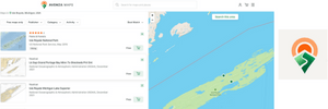
- Best Trail Planning Map App for Isle Royale: Alltrails
Maps from the National Park Brochures
This is the latest 2024 Isle Royale map (650 kb) included in the current National Park brochure, identifying campgrounds, trails, ferry routes, portages, lakes and amenities. It is helpful for planning, less cartoony than the previous Isle Royal map but a little bit harder to read. There is no mileage on this map.
This is the previous official Isle Royale National Park map (600 kb)from the brochures, including campgrounds, trails, ferry routes, portages, lakes and amenities. I’ve included it because it is higher contrasting colors than the current one, making it easier to read. There is no mileage on this map.
Ferries and Seaplanes Map
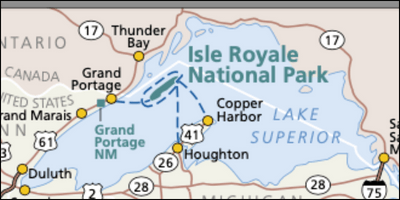
When you’re trying to figure out how to get to and from Isle Royale, use the regional ferry and seaplane route map (50 kb)to plan your trip.
It can be a little confusing to reach Isle Royale as you cannot drive to the national park. Instead, you leave your car on the mainland and take a ferry or seaplane across Lake Superior.
The regional map of Isle Royale shows Lake Superior, ferry routes from Houghton, MI, Copper Harbor, MI and Grand Portage, MN. It also shows seaplane routes from Hancock, MI and Grand Marais, MN.
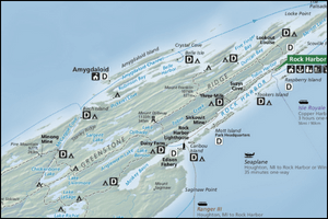
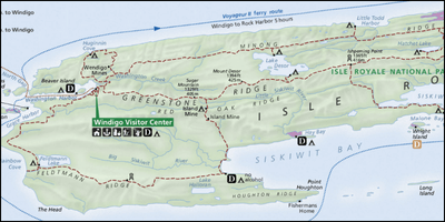
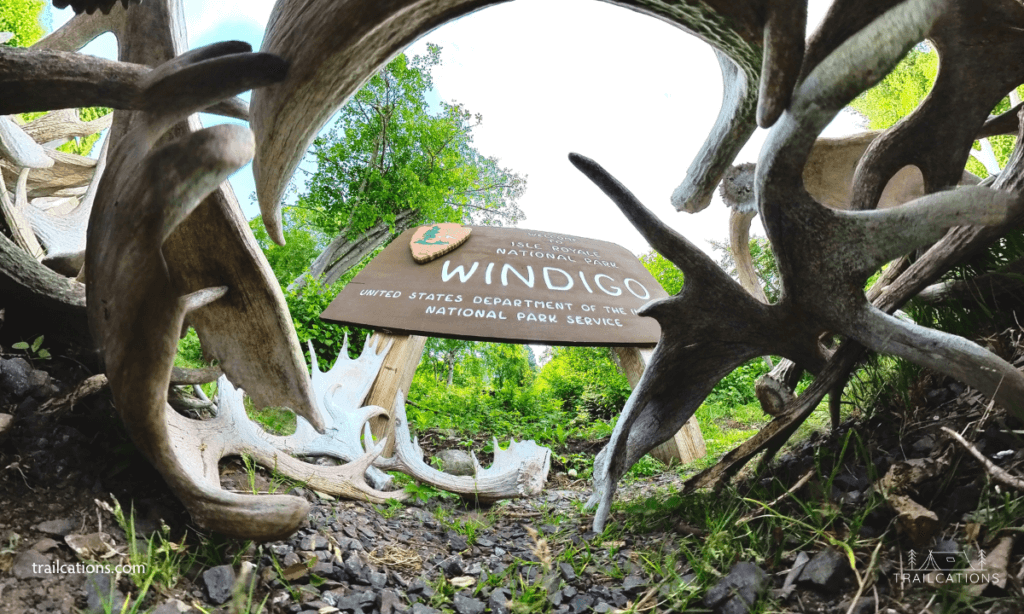
Detailed Isle Royale Maps of Windigo and Rock Harbor
99% of Isle Royale National Park is federal wilderness. There are two areas on the island with limited amenities and lodging where the ferries and seaplanes land: Rock Harbor and Windigo.
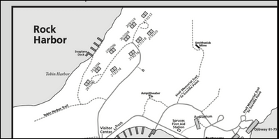
This is the detailed map of the Rock Harbor area (1.9 mb), one of the closest areas to a “town” on Isle Royale. It includes trails, amenities, campsite locations, scenic overlooks and points of interest near Rock Harbor on the northeast side of the island.
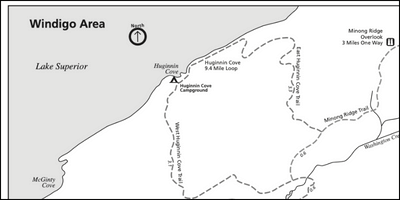
This is a detailed map of the Windigo (600 kb) area, a developed region on the southwest side of the island that is less crowded than Rock Harbor. The map includes trails, amenities, campsite locations, scenic overlooks and points of interest in the Windigo area near Washington Harbor.
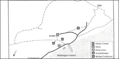
This is a map of the Windigo Nature Trail (300 kb)with various points of interest that you’ll see on your hike.
Isle Royale Trail Maps for Hiking, Backpacking and Canoeing
Isle Royale is a popular bucket list destination for backcountry hikers and paddlers and a detailed trail map like the waterproof paper National Geographic Trails Isle Royale National Park Illustrated Map is a must-have for packing with you into the wilderness.
This official map of Isle Royale shows mileage, topography, trails, distance between trail junctions, points of interest, water depths, canoe portages, amenities and campgrounds. With zero cell service and no wifi on the entire island, you will definitely need this waterproof map for navigating.
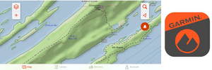
The best free navigation apps for Isle Royale National Park are Garmin Explore‘s maps. They show topography, satellite view, campgrounds and water sources but don’t have mileage labels like the Nat Geo map.
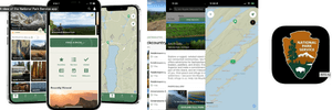
A must-have map with key areas of interest would be the offline Isle Royale National Park map downloaded from the NPS App. However, don’t rely on this map for much detail on mileage or topography.
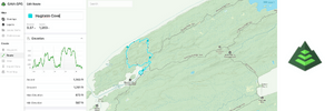
The best paid navigation app for Isle Royale would be the offline maps from Gaia GPS where you can create your own custom GPX tracks for your backpacking or hiking trip before leaving the mainland.
Another great navigation app for Isle Royale is downloading the digital version of the National Geographic Trails Isle Royale map on the Avenza Maps app.

Here is the Isle Royale relief map (1.5 mb) that removes all the details except for the island’s physical geography. This will help you understand how rugged the island is, making it easier to see the layout of the parallel “mountain” ranges.
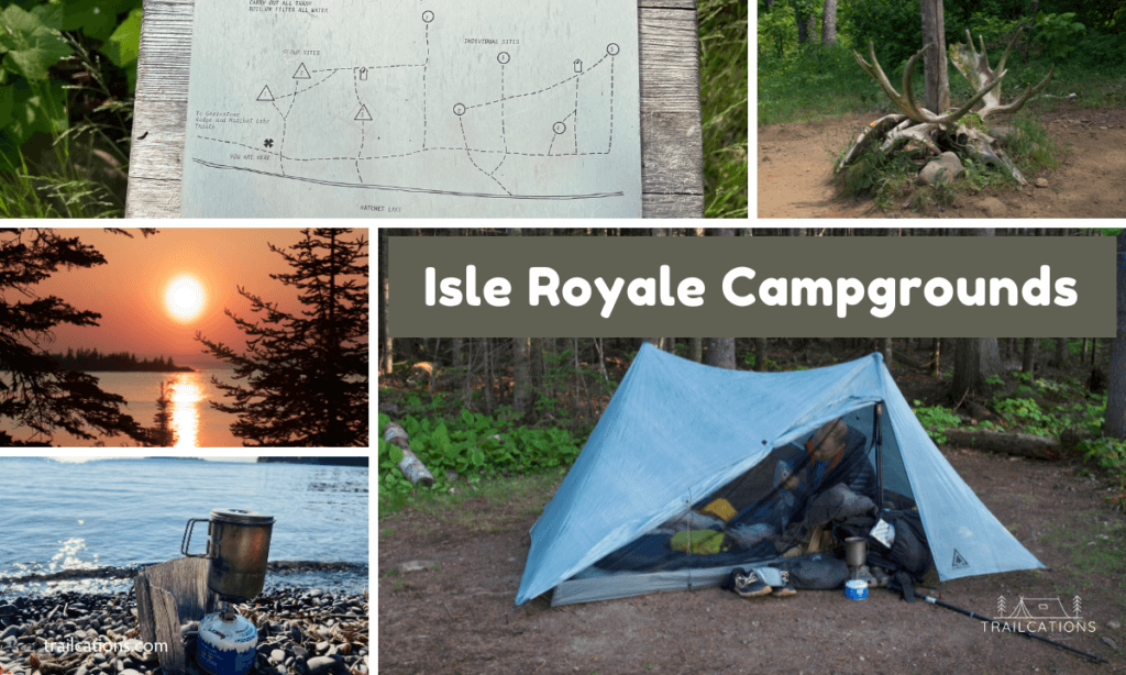
Campgrounds of Isle Royale Map
If you’ll be backpacking, hiking or camping, you’ll want to familiarize yourself with the campgrounds of Isle Royale maps.
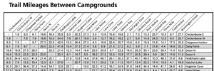
Here’s the trail mileage between campgrounds chart (500 kb)for planning your Isle Royale backpacking and camping trips. However, we found the National Geographic topographic map and Gaia GPS maps to be a bit more accurate, usually leaning to the shorter side compared to the trail mileages chart.
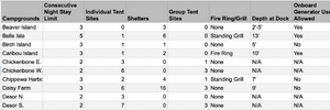
This is the full list of the 35 Isle Royale campgrounds (850 kb)with their amenities, number of sites and maximum nights stay. Combined with the National Geographic topographic map, this should help you to easily plan out your hiking or backpacking trip.

If you visit Isle Royale during one of the popular months of July and August, you may find the campgrounds to be a little crowded. This cross-country camping zone map (750 kb)will help you understand where you can and cannot do dispersed camping in case the established campgrounds are full.
Curious about camping, backpacking and hiking on Isle Royale National Park? Check out our trail-tested resources to plan your next outdoor adventure on Isle Royale:
Isle Royale Lodging Map
Isle Royale is challenging to get to, especially since cars are not allowed on the island. Most visitors ride a ferry boat from Michigan or Minnesota. There is limited on island lodging. However, in the various towns near the ferry and seaplane terminals on the mainland there are certainly more lodging options.

Mainland Lodging Map – check out Booking.com, Kayak.com, Airbnb, etc.
- Copper Harbor, MI
- Houghton, MI
- Hancock, MI
- Grand Marais, MN
- Grand Portage, MN
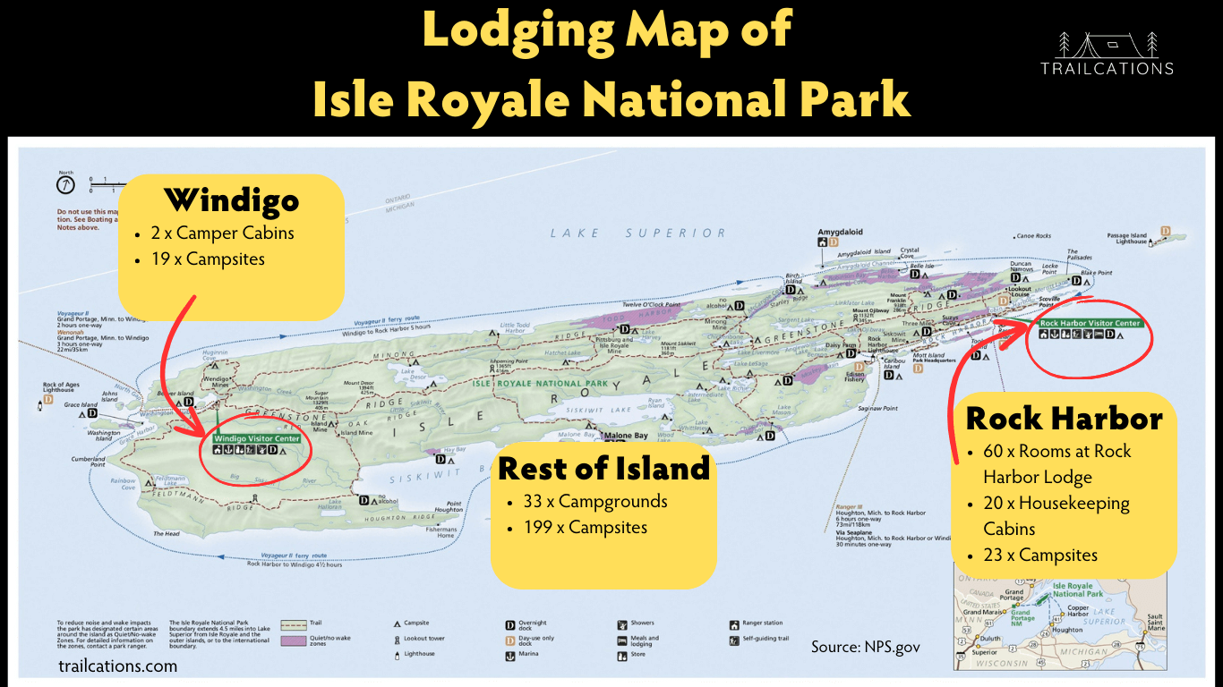
On-Island Isle Royale Lodging Map (900 kb)
- Rock Harbor, Isle Royale
- Windigo, Isle Royale
Planning a trip to Isle Royale? Check out our honest opinions about the Isle Royale accommodation options here.
Points of Interest Isle Royale Maps
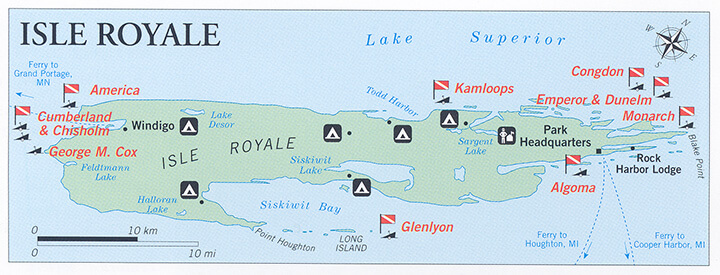
This is the Isle Royale scuba diving map (100 kb) showing the locations of 10 shipwrecks you can explore around the island. Due to the cold water temperatures and remote location, only experienced divers should consider these diving sites.
Learn more about Isle Royale scuba diving and the island’s shipwrecks here.
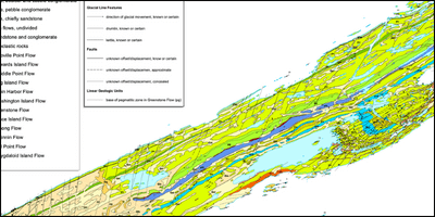
The Isle Royale geologic map (6.9 mb) is highly detailed and worth a look for the rock minded individuals, especially those interested in the area’s 4,500-year-old copper mining history. There is a huge amount of diversity in rock types from lava flows to sandstone conglomerates in this small area of the national park.
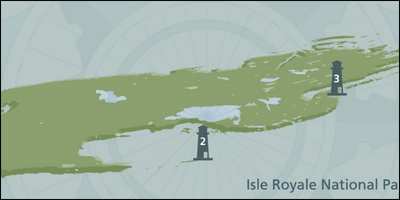
The Isle Royale lighthouse brochure map (1.9 mb)is interesting for a quick browse to plan out a ferry ride or boat tour to visit one of these beautiful towers. If you have time, plan out a boat sightseeing tour or sunset cruise to visit the barrier islands and lighthouses.
Birdwatching and Stargazing Maps

The eBird Hotspots map highlights birding hotspots from around Isle Royale. Since this is an open-sourced map, you may be able to find dynamic information on both resident and migratory birds, no matter what time of year you visit.

The Dark Sky Map indicates where the darkest skies are on Isle Royale. This map is based on light pollution from neighboring cities or human settlements. Isle Royale’s remoteness makes it one of the best dark sky observation sites in the midwestern United States.
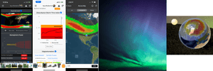
The Auroral Oval Map on the SpaceWeatherLive App will indicate if you’ll be able to spot the northern lights while on Isle Royale. Keep in mind there’s no cell service on this island and wifi for Rock Harbor Lodge guests only. Also, many of the Park Rangers love the northern lights and will be able to give you a better idea of upcoming solar storms, even if you can’t access your phone’s data.
Vision Impaired Maps

There are several low-vision, braille or audio only maps available for those with vision impairment or blindness. Most are available online and physical copies can be requested from the park via the above link.
Traveling with someone with a disability? Make sure to review our Isle Royale Accessibility Guide so you understand how to plan a seamless, stress free visit to this remote national park and have an amazing time while you’re there.
Understanding Isle Royale National Park
Isolated in the rugged heart of Lake Superior is a nature reserve adored by many and known to few. This treasured wilderness area, snug in the town of Michigan, is none other than the Isle Royale National Park.
The park’s unique geographical positioning offers outdoor enthusiasts unparalleled opportunities for recreational pursuits, right from hiking trails to wildlife spotting sites.
Boasting diverse flora and fauna, the park is also home to multiple camping locations that draw visitors throughout its open season.
However, as enticing as it sounds, don’t expect any flashing neon signs guiding you comfortably through this national park. That’s where Isle Royale maps come into play.
How Many Miles Across is Isle Royale?
Isle Royale is an island that is 9 miles wide by 45 miles long (15 km wide by 72 km long). It is a remote island archipelago situated in Lake Superior about 14 miles (24 km) from the nearest mainland in Ontario, Canada. Check out these article to learn more about Isle Royale facts or Isle Royale’s history.
How Many Miles of Trails are there on Isle Royale?
There are over 165 miles (265 km) of hiking and backpacking trails on Isle Royale. They are very rugged trails with roots, rocks and steep ups and downs.
99% of Isle Royale is wilderness with no roads, just trails, so backpackers and hikers need to be extremely self-sufficient here. Due to the wilderness status, no bikes, wheeled devices or vehicles are allowed.
Wheelchairs are allowed on the trails but it is recommended to stay in the Rock Harbor or Windigo areas. The trails are too rugged and narrow for even the most heavy duty of motorized wheelchairs. Learn more about Isle Royale accessibility for inviduals with disabilities.
How Long Does it Take to Walk Across Isle Royale?
Typically it takes backpackers about 4 to 6 days to walk across Isle Royale. Backpackers will begin their journey at Rock Harbor or Windigo, following the Minong Ridge or Greenstone Ridge approximately 40 miles (64 km) from one end of the island.
Interested in planning a backpacking trip to walk across Isle Royale? Check out our Isle Royale backpacking tips, tricks and itineraries we created after backpacking around the entire island of Isle Royale.
The Importance of Having a Map for Isle Royale Adventures
Being equipped with an Isle Royale map during your visit isn’t just a suggestion; it’s a necessity. This wilderness area isn’t just your backyard picnic spot. It’s a haven for backcountry camping and hardcore hiking trails.
The park rangers give a mandatory safety talk to every visitor arriving on the island by ferry, stressing the remoteness of the island and limited park resources. They don’t sugarcoat anything. If you get injured on the island, it could take several hours to several days to rescue you.
With its diverse terrain, lack of cell service or wifi and expansive landscapes, getting from point A to point B in Isle Royale can be challenging without proper navigation tools. There are no roads. The ferries require advance reservations and planning, often selling out months in advance.
To make your experience enjoyable rather than exhausting, carrying an Isle Royale map is crucial. Moreover, possessing an understanding of how to read these maps can significantly influence your journey.
Maps can aid in planning your island itinerary, whether you aim to blaze every trail or pitch your tent at the most serene campsites. Also, they can help you spot those elusive wildlife creatures that call this park home.
Types of Maps Available for Isle Royale Visitors
There are plenty of Isle Royale maps available to guide you through your journey. Ranging from physical versions for traditionalists to interactive digital maps for tech enthusiasts, several options cater to different visitor needs.
High-resolution National Park maps, available online and offline, feature intricate details about every trail, campground, topographical features and other essentials within the park. More so, there are map sets that cover different regions of Isle Royale, like East, Central, and West areas.
For the visually impaired visitors, braille as well as audio-only and text-only versions of Isle Royale Unigrid brochure are also available online.
Pro Tip: Due to limited resources on the island, I recommend purchasing or downloading ALL of your maps ahead of your visit. There is no cell service or wifi once you leave the mainland. Make sure to pack a power bank and cables if you’ll be backpacking with your phone. Check out our free Backpacking Checklist Printable PDF to help with planning your Isle Royale trip.
However, if you get on island and realize you forgot your map, check out the general stores or an Isle Royale Visitor Center as your first stop to acquire these valuable guides.
Alternatively, websites like AllTrails offer in-depth digital guides about outdoor recreation in Michigan’s most extensive nature reserve.
Where To Find Physical and Digital Maps of Isle Royale
Finding a map that suits your requirement isn’t rocket science. If you prefer holding a physical map in hand while journeying through Isle Royale’s wilderness area; official national park visitor centers, local shops or online platforms dealing with travel guides should have them in plenty.
However, it is recommended that you carry a paper topographic map with you in the backcountry on Isle Royale because electronics can break or die, and there’s no cell service or wifi on the island. We found that the waterproof National Geographic Isle Royale National Park map was the best for backpacking and hiking.
Pro Tip: Download and purchased all your maps before you leave the mainland. There is no wifi or cell service on the entire island, unless you’re staying at Rock Harbor Lodge. Isle Royale’s general stores and Visitor’s Centers have limited resources for paper maps that can dwindle later in the summer.
For visitors favoring digital maps, AllTrails is a fantastic place to start for planning. Equipped with reviews and photographs from past explorers, this platform provides an excellent overview of many trails throughout the park.
Moreover, there are numerous smartphone apps like Avenza that offer offline topographic maps too. Also, check out comprehensive books possessing a wealth of information about the park, available for purchase online.
How to Get to Isle Royale Map: Ferry Routes, Seaplane Airports
Half the adventure is just getting to Isle Royale in the first place! To learn more in detail about getting to Isle Royale, check out our comprehensive article about all the ways you can get to and from Isle Royale, plus 20 Expert Travel Tips we wished we knew before going to Isle Royale.
What is the Best Way to Get to Isle Royale?
The best way to get to Isle Royale is either by ferry, seaplane or private boat. Seeing as Isle Royale is located about 20 miles (32 km) offshore in Lake Superior from the nearest dock, you cannot drive to Isle Royale – you leave your car on the mainland. The ferries and seaplanes are for people only.
What Airport Do You Fly Into for Isle Royale?
To reach Isle Royale by plane, you actually hop on a small seaplane. The seaplanes leave from Grand Marais, MN and Hancock, MI and will land in the harbors of either Windigo or Rock Harbor.
What City is Closest to Isle Royale?
The closest city to Isle Royale is Grand Portage, Minnesota, a 2 hour ferry ride away from Windigo in Isle Royale. However, calling it a “city” is certainly generous with its tiny population of 700 people. There is no wifi or cell service in Grand Portage, unless you’re staying at the casino hotel on the Grand Portage reservation.
That being said, the closest city to Isle Royale in Minnesota would be the north woods vacation destination of Grand Marais with its population of 1,400. It has restaurants, grocery stores, small outfitters and many options for lodging, vacation rentals, a hostel and cabins spread out between the downtown and neighboring Gunflint Trail in the Boundary Waters Canoe Area.
The closest city to Isle Royale in Michigan would be Copper Harbor (a 3.5 to 4 hour ferry ride) or Houghton (a 6 hour ferry ride). Copper Harbor is a small vacation town of 125 people with lodging options, basic amenities, a general store and a couple restaurants. You’d be better off staying in the Houghton-Hancock area where there are more options for hotels, outfitters, grocery stores and other amenities being a larger city of 7,600 people.
How Long Does the Ferry Ride Take to Get to Isle Royale?
How Long is the Ferry Ride From Copper Harbor to Isle Royale?
The ferry ride from Copper Harbor, MI to Isle Royale takes about 3.5 to 4 hours one way on the Isle Royale Queen IV. The ferry lands in Rock Harbor on Isle Royale.
How Long is the Ferry Ride From Houghton to Isle Royale?
The ferry ride from Houghton, MI to Isle Royale takes about 6 hours one way on the Ranger III. This ferry docks in Rock Harbor on Isle Royale.
How Long is the Ferry Ride From Grand Portage to Isle Royale?
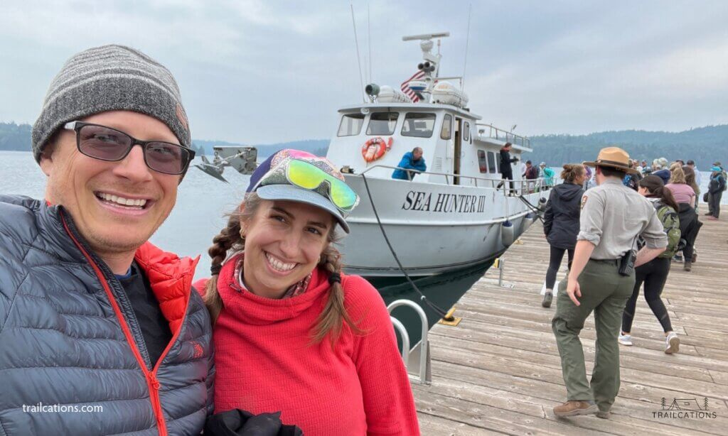
The ferry ride from Grand Portage, MN to Isle Royale takes about 1.5 to 2 hours one way. The Voyageur II takes 2 hours and the Sea Hunter III takes 1.5 hours, both landing in Windigo. The Voyageur II also circumnavigates the entire island, stopping at various harbors including Rock Harbor.

How to Read Topographical Maps of Isle Royale
Reading a map isn’t just about spotting where you are and figuring out where you need to go. It’s about understanding the terrain you’re traversing. In this context, topographic maps can be immensely helpful.
Topographic maps feature contour lines in addition to the usual icons and notations. These lines indicate elevation changes on the land surface – crucial information if your day involves hiking!
The key to reading topographic maps lies in understanding these contour lines. Closely spaced lines represent steep slopes while farther apart ones imply more gradual slopes. The rest is all about following landmarks as you navigate through your adventure.
Navigating the Trails with Isle Royale Trail Maps
An Isle Royale trail map shows all available hiking trails in the park. With the varied terrain and different difficulty levels available at Isle Royale National Park, these maps are indispensable in planning your hiking itinerary.
Listed on these maps are key information such as trail distances, difficulty level, water sources and prominent features you’ll encounter.
Remember to pick a trail well-suited to your experience and endurance levels. More importantly, ensure you’ve reviewed the relevant trail map thoroughly before embarking on the hike. A smart hiker is one who’s prepared!
Water Navigation: Using Nautical Charts Around Isle Royale
Isle Royale isn’t all about land trails. Its location in the heart of Lake Superior calls for nautical chart navigation too. If you’re planning to explore the waters around the island, familiarize yourself with reading a nautical chart.
These charts depict water depths, hidden dangers beneath the surface and critical navigational aids like buoys and beacons.
Lake Superior is the smallest body of inland water that has discernible tides. However, they typically only vary by 2 inches (5 cm) so you don’t have to worry too much about them.
Moreover, take into account incoming local storms, gale warnings and wave height effects. Being on an island in the middle of this great lake, weather can quickly change, stirring up waves over 20 ft (6 m) tall. Remember, safe water navigation requires a thorough understanding of these nautical documents and weather conditions.
Pro Tip: The free nautical maps on Avenza Maps are good tools for paddling around Isle Royale National Park.
Planning Your Trip with Interactive Online Maps of Isle Royale
The Isle Royale Interactive Online Maps tool acts as a decent park navigation map. However, don’t expect to get a whole lot of info out of this to help plan your trip efficiently. These maps usually encompass some details about trails, campsite locations and geography.
I found using the following map tools to plan my Isle Royale backpacking trip immensely more helpful than the Interactive Online Maps tool.
- National Geographic Isle Royale National Park Paper Map – only tool that shows mileage on the topographic map
- AllTrails – best for picking out hiking trails
- Gaia GPS – best for plotting out GPX tracks and custom routes
- Garmin Explore – best for navigating on island and seeing water sources, terrain
- Avenza Maps – best for digital version of the National Geographic Topo map
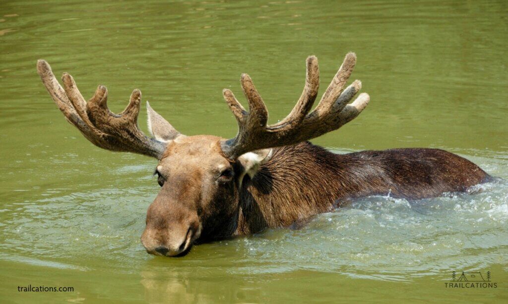
Wildlife Viewing on Isle Royale and How to Use Maps To Find Them
Isle Royale National Park is inhabited by an abundance of wildlife — from moose and wolves to a multitude of bird species. Knowing where these creatures are mostly found can significantly enhance your wildlife viewing experience.
Currently there are no public wildlife maps that track Isle Royale large animal sightings such as moose or wolves. However, the park service websites indicate habitats and common spotting sites of various animals within the park. They also include safety tips and viewing etiquette, helping ensure your encounters are respectful and non-disruptive to the wildlife.
If birding is your interest, check on apps like eBird’s Hotspots Maps. You’ll find specific dynamic maps marking bird-rich areas as well as seasonal birds to keep an eye out for. In essence, these maps can turn your casual hikes into rewarding nature watch excursions!
Campsite and Shelter Locations on the Island’s Map
Having an Isle Royale map marked with campsite locations is vital for backcountry camping adventures. Identifying where shelters are placed along the trails can help you plan out stops during multi-day hikes.
All campsites have backcountry water sources, tent sites and pit toilets. However, some may not be large enough for groups so be sure to check out the backcountry permit situation and Isle Royale campground guide for more information.
Moreover, specialized camping maps may even grade campsites based on amenities or views offered — this could serve as a handy guide for picking out your perfect campsite spot.
Isle Royale’s Weather Patterns and How They Affect Your Map Usage
The weather on Isle Royale can be unpredictable. Weather patterns strongly influence trail conditions and navigability (and whether you can even access the island!). It’s crucial to keep tabs on the usual weather patterns.
Some interactive maps integrate live weather updates or season-specific information, which can be highly beneficial. We like using the Windy app or Weawow app to get National Park specific weather.
Some big name weather apps won’t show weather actually in the national parks; instead they’ll show the town nearest to the park. They also tend to have too many annoying ads.
Remember, being aware of possible weather changes helps ensure your adventures are safe – as exciting as they can be!
Using GPS vs. Paper Maps on Isle Royale: Pros and Cons
Digital maps and GPS have revolutionized navigation worldwide. Yet, when it comes to navigating through remote and rugged locations like Isle Royale, traditional paper maps hold their ground.
Digital map apps ensure convenience with features like live tracking and interactive interfaces. However, they are dependent on device battery life and signal availability.
On the other hand, paper maps require no signal or power supply and are always available for reference. Their downside? They lack real-time updates and might be cumbersome to handle during an active hike.
Paper Maps on Isle Royale
Pros of Paper Maps on Isle Royale
- Don’t have to rely on electronics which can die or break
- Most are waterproof and show excellent detail
- Mileage and side trails are listed with important information
Cons of Paper Maps on Isle Royale
- Doesn’t show your real time GPS location
- Cumbersome to fold and unfold when you want to use for navigating
- No real time trail updates provided
Digital Maps on Isle Royale
Pros of Digital Maps on Isle Royale
- Shows exact real time GPS location
- Easier to access to navigate while hiking
- Can zoom in on details
Cons of Digital Maps on Isle Royale
- Consumes cellphone battery charge
- Electronic device can break, get lost or lose power
- Typically no mileage listed on navigation apps
- Also no real time trail updates because of lack of cell service and wifi on entire island
Your choice between digital or paper Isle Royale maps should depend on your preferences and comfort level with each medium. We suggest using both digital AND paper maps for your Isle Royale backpacking, hiking or paddling trip.
With this comprehensive guide to Isle Royale Maps at hand, you’re all set for a well-informed adventure in Michigan’s hidden wilderness gem.
FAQs
What types of maps are available for Isle Royale?
High-resolution National Park topographic maps that highlight trails, campgrounds, and other key features are available. You can find topographic maps that are waterproof and tear-resistant, ideal for hiking. Map sets covering East, Central, and West Isle Royale are also provided. For a unique perspective, custom printed maps with a 3D topographic look can be purchased.
Can I access Isle Royale maps digitally for offline use?
Yes, you can view the park’s maps online or download them for offline use through apps such as Avenza. These digital versions include detailed information about the park’s main trails and campsites.
Are there resources available for visually impaired individuals visiting Isle Royale?
Indeed, there are Braille versions, as well as audio-only and text-only versions of the Isle Royale Unigrid brochure, which can be accessed online to accommodate visitors with visual impairments. To learn more about Isle Royale Accessibility for people with disabilities, including lodging, amenities and things to do, check out our Isle Royale Accessibility Guide.
Where can I find trail reviews and photographs from previous visitors to Isle Royale National Park?
AllTrails offers hand-curated trail maps alongside user-generated reviews and photographs. This resource is beneficial for those interested in birding or camping in addition to hiking.
Why is it important to examine a map before visiting Isle Royale National Park?
Examining a map beforehand allows you to familiarize yourself with the areas you wish to explore. It helps in planning your itinerary effectively and ensures that you make the most out of your visit by targeting specific wildlife spotting sites or scenic hikes. Since there is no cell service or wifi on the entire island, you’ll need to have planned out your hikes, backpacking itineraries and canoe trips before hand.
When is Isle Royale closed to visitors, and why?
Isle Royale is closed annually from November 1 – April 15 due to extreme weather conditions making it inaccessible; however, Lake Superior waters remain open to boaters during this time. Waves towering over 25 ft (7 m), ice pack, ice bridges, icebergs, blizzards and freezing spray are all winter hazards preventing access to Isle Royale. This closure ensures visitor safety while allowing natural processes to occur without human interference.